

Wiltshire Local Development Scheme
2 July 2022
The formal route for Pry Farm to become a new development area is to have it included in the Wiltshire Local Development Scheme.
This document, dated November 2021, sets out the timescales for adopting the scheme.
Land at Pry Farm Sold
30 June 2022
See this link, which has no date, describes the land as sold as ‘future potential residential land’.
New proposals for westward expansion of Swindon as developer proposes 3,000 houses at Pry Farm to be included in the Swindon and Wiltshire Local Plans
11 June 2021 (modified 16 June 2021)
A house building company (Mactaggart & Mickel) has written to Swindon and Wiltshire councils requesting each council’s 2036 Local Plans include a development, consisting of 3,000 homes, just to the west of Haydon Wick / Thamesdown Drive at Pry Farm. Their letter can be viewed by clicking here.
Please note: this is a proposal from a developer for the land to be allocated as part of the Local Plan, and not a formal planning application. However, we are aware that the developer has started talks with Councillors and Parish Councils, but it is early days and no public consultation has yet been announced.
A council’s Local Plan is the principal planning policy document for the authority. More information can be found by clicking here (for Swindon) and here (for Wiltshire). Simply put – if it gets into the Local Plan, it gets built.
The proposal is likely just the start of a process that, if adopted, will see Swindon join with Purton and Cricklade by 2050
Both Swindon and Wiltshire are conducting reviews of their 2036 Local Plans, and this submission has been made as part of that review. The full representation report from DPDS on behalf of Mactaggart and Mickel can be viewed by clicking here. Within this document are the following quotes:
“Initial survey work has been carried out, notably in connection with developing an access strategy to facilitate early development of at least a part of the site and to set the overall context for a larger, more strategic development that may emerge from the Development Plan process”.
And in relation to Swindon’s current 2036 local plan: “The estimate of local housing need is a minimalist figure and should be considerably higher”.
“….notably the significant evidence contained in the “Gold” and “Silver” Reports of 1966 and 1968 respectively which looked at the concept of large scale expansion of Swindon, pointed to future westward expansion of the town; …… lies an area regarded as suitable for the purpose of the expansion. It is the western sector, which contains Lydiard Millicent and Purton”.
DPDS
Despite the following assertion in the Mactaggart & Mickel letter..

“Pry Farm would not extend as far as the village of Purton ensuring a substantial ‘green gap’ is maintained between the village of Purton and Pry Farm”.
Mactaggart & Mickel
..the strategic goal of the developer, supported by DPDS is clear – the considerable expansion (much more than the proposed 3,000 homes) to the West of Swindon, ultimately resulting in coalescence with Purton and Cricklade by 2050.
Furthermore, for DPDS to be citing reports that were drafted nearly 60 years ago, just because they support their particular narrative, is preposterous, cynical, and unhelpful. Swindon, Wiltshire and the UK are all very different to how they were in the 1960s. For example, the 4,000 houses at Wichelstowe, 8,000 proposed for the Eastern villages, and Badbury Park near Coate Water, were not part of the 1960s ‘vision’, but we do not hear developers claiming they should not have been built!
Moreover, since the 1970s, Swindon’s western expansion, starting with Toothill, has been dramatic, and is now home to nearly 30,000 people (if Ridgeway Farm and Mouldon View are included).
How to voice your opinions
Swindon Borough Council will be conducting a revised consultation in August / September, where views should be expressed. However, if you have strong views about this proposal (for or against), and wish to voice them now, you should contact your local Swindon Councillor or Wiltshire Councillor.
The SRA is not supportive of this proposal for the following reasons
- It will have a devastating effect on Mouldon Hill Country Park: the primary access to the development would be through the Park, and houses will be built right up to the lake and surround the wooded area to the north of the lake. Consequently, the word ‘country’ would have to be changed to ‘town’.
- Thamesdown Drive, Akers Way and Mead Way are already massively congested with traffic. Indeed, Mead Way was deemed over capacity before Ridgeway Farm was built (700 houses). The addition of 3,000 houses without any major new roads / west Swindon bypass (e.g. A419 to M4 J16 link), will significantly affect the quality of life of all West Swindon residents.
- It is not a sustainable location: For example, due to the location of the boundary between Swindon Borough Council land and Wiltshire Council land, nearly 90% of the houses will be built in Wiltshire. The proposal does not include a secondary school. Therefore, all secondary school children will have to travel by road (bus or car) to Purton. Alternatively they will need to seek a placement in one of several Swindon secondary schools, with only one being in a reasonable walking / cycling distance for those houses built on the eastern-most part of Pry Farm only. Other infrastructure considerations also come into play, as outlined below.
- A recent proposal to build 79 houses just north of Purton Road has been rejected twice by Wiltshire Council and once by a planning inspector following an appeal. One of the many reasons for refusal cited by the planning Inspector was ‘there was no need for further development west of Swindon. Even if there was, the proposed area was not representative of a sustainable option’ – therefore, this proposal for a development nearly 40 times bigger, and only a few hundred metres from the rejected area, must be dismissed on similar grounds.
- This proposal is a very large trojan horse. The longer term goal is much greater (as made clear by DPDS). It will lead to the eventual coalescence of Swindon with Purton, Purton Stoke, and Cricklade. It will also require a West Swindon bypass between Cricklade A419 and the M4 Junction 16 – such a road would have a catastrophic impact on the rural life of the aforementioned villages, as well as Lydiard Millicent and Hook.
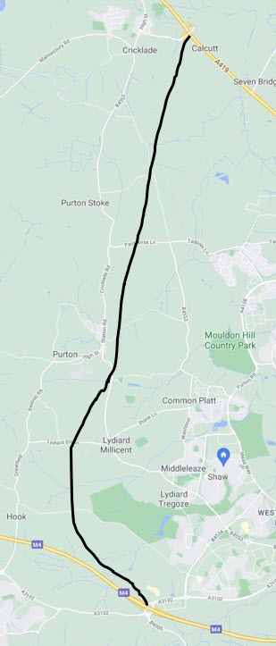
- The location of the proposed development occupies yet more of the River Ray flood plain. Continually building along the coarse of the River Ray can only lead to more flooding further downstream, or water backing up into residential areas such as Roughmoor, Haydon Wick, Gorse Hill, Westlea, and Wichelstowe.
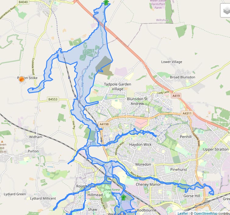
Flood water
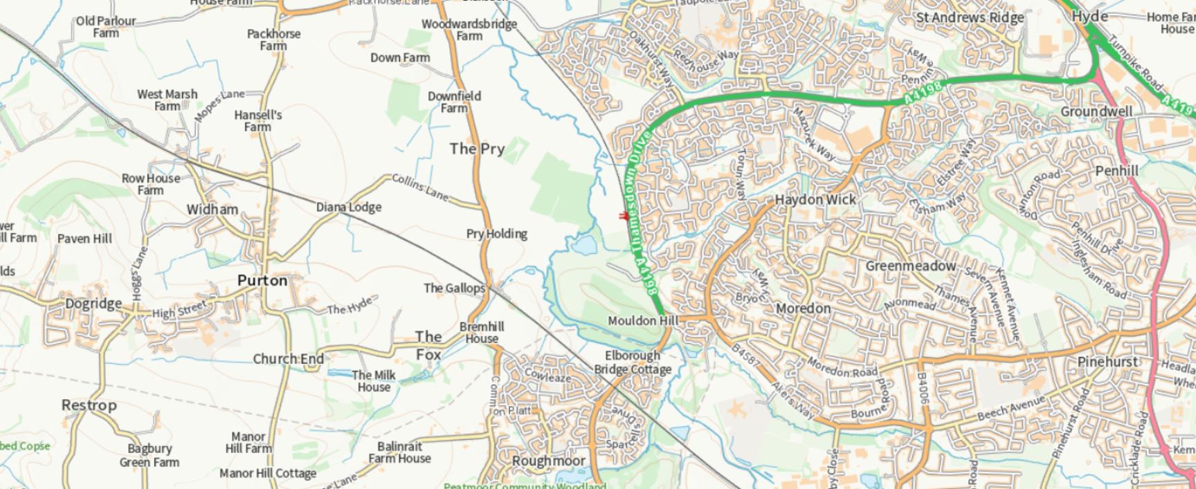
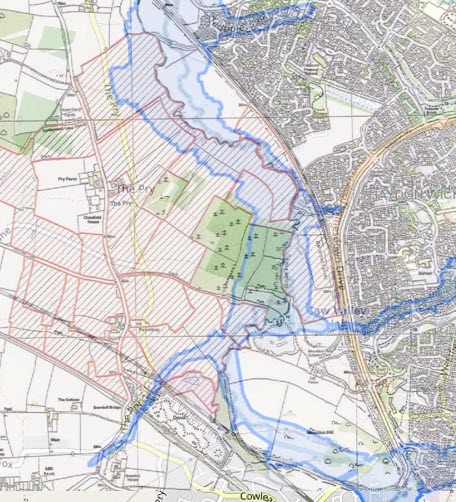
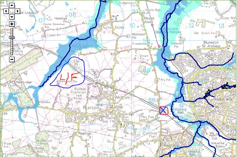
Much of the proposed development is on the River Ray flood plain. The map below on the left is the flood plain as defined by riverlevels.co.uk and the one on the right is the proposed development overlaid onto that map.
The map below is provided by the Environment Agency depicting the Purton area flood zones.
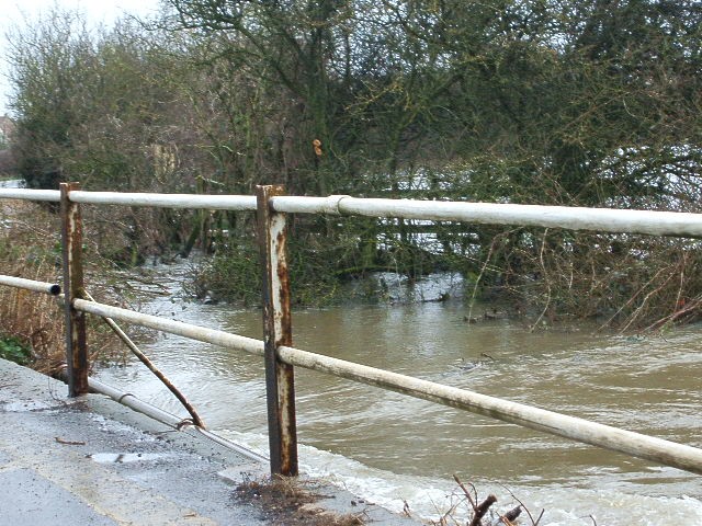
The photos below were both taken in March 2008. To the left are the floods at Tadpole Bridge, on the east side of the railway and south side of the road. The picture on the right looks from Elborough bridge on Purton road.
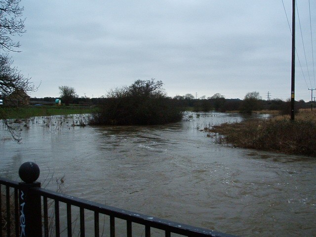
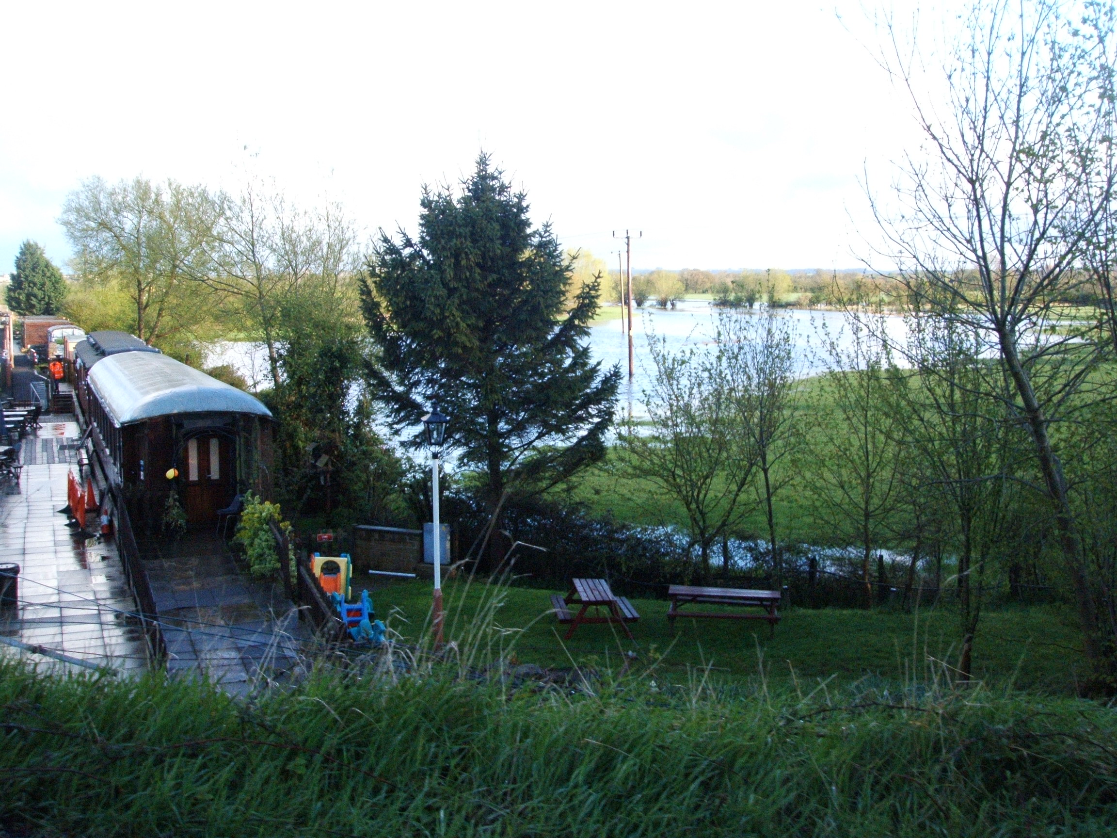
The photos below show the fields adjacent to the Cricklade and Blunsdon Historic railway, the floods on the left are from March 2009, and the fields on the right just one month earlier in February 2009.
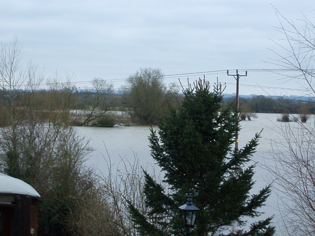
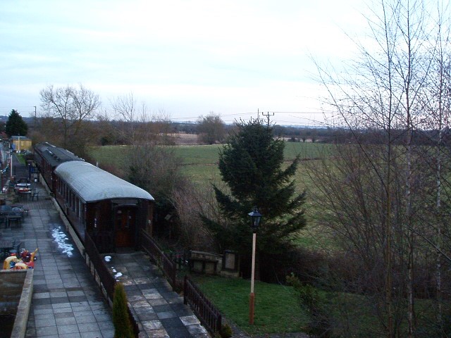
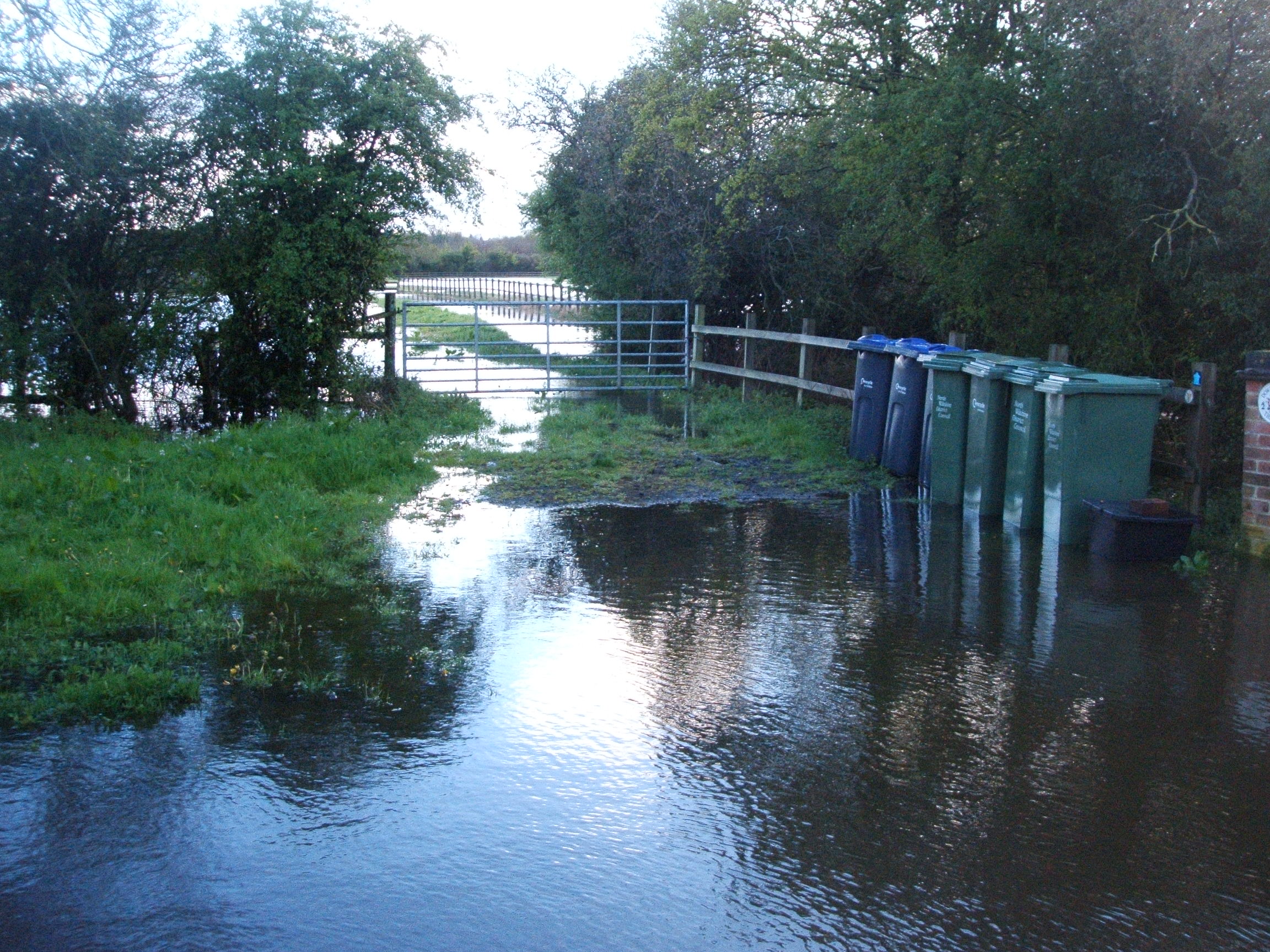
Both of the photos below were taken just three years later in April 2012. The one on the left shows floods near the heritage railway and the one on the right is on the Pry at the bottom of the road that leads to Downs Farm.
Infrastructure
Local Authority
As noted in point three above, most of the development will be in Wiltshire and not Swindon (note: all of Ridgeway Farm and Moulden View are in Wiltshire). This means 90% of Council tax will go to Wiltshire Council rather than Swindon, even though the proposed development will rely mostly on Swindon’s infrastructure. It is necessary to create a ‘sense of belonging’, and so, a decision needs to be made about which authority this development belongs to.
Roads
The reason roads become so congested is because developers justify their small-scale proposals based on them having ‘minimal’ impact on the road infrastructure (e.g. Ridgeway Farm and Mouldon View).
The link between the southern end of Thamesdown Drive and Great Western Way did not get built as part of the Northern expansion, largely due to cost. The amount in the Section 106 legal agreement with the developer consortium negotiated by Wiltshire Council, which was the highway authority at the time, was far too low to cover the cost of providing the road. Should it get built today, even without more houses to the north and west, it will simply move the congestion to the Barnfield junction at Great Western Way (unless the Great Western Way junctions between Barnfield and the M4 also get upgraded).
A major question is who would pay for a junction on Thamesdown Drive and an access road to Pry Farm, crossing the River Ray, the Swindon & Cricklade Heritage Railway, and a significant flood plain. Would the return from building 3,000 houses make such a proposition financially viable for any developer? Or is this yet more evidence of a much larger end goal?
Furthermore, to imagine that such a large scale development of 3,000 houses can be bolted onto west Swindon without a west Swindon bypass (e.g. a direct link via a new road from the A419 to the M4 J16), is to take a blinkered approach to the issue. But, as noted above, it is clear the development will not stop at 3,000 houses.
But then there becomes the problem of coalescence of Swindon with the surrounding villages. Where would such a bypass run? Whose homes, and what villages will be devastated by it? The problem and the choices are clear. To expand Swindon to the west and destroy more pristine countryside for houses requires even more countryside to be converted into roads. That must be a political decision and not a developer / Planning Inspector decision.
Schools
The applicant proposes including a primary school as part of the development, but there is no mention of a secondary school. Dependent upon on the rule-of-thumb used, 3,000 houses will generate somewhere between 630 and 840 primary school children. Given that the average primary school in the UK is 281 pupils, this proposal will require not one but up to THREE primary schools.
Furthermore, and again dependent upon the calculation used, 3,000 houses will generate between 300 and 600 secondary school places. Such numbers would occupy between 30% and 60% of an average sized secondary school (assumed to be 980 pupils). Therefore, to assume existing schools, be they in Wiltshire or Swindon, could accommodate all these new pupils without significant investment in capacity, paid for by the developer, is fanciful at best.
Other Infrastructure needs
- A development of this size would have to include at least one community centre with local amenities, such as grocery stores, personal care, a public house, a community hall, and potentially a place of worship.
- Water supply and sewage treatment would need to be upgraded – there have been many reports of problems with capacity.
- Can Great Western Hospital cope with such a dramatic increase in the population. What about Doctors surgeries, and dentists?
- The expansion would be in Wiltshire and so household waste collection would have to be taken to Wiltshire’s recycling centres and not Swindon’s.
- Open space management: with the move for public open spaces replacing decent sized gardens comes the issue of maintenance. Ridgeway Farm is a case in point, where boundary hedges and children’s play areas are not being maintained, because the developer seemed unaware that the council did not own them and, therefore, would not be maintaining them.
- Parking and garaging: with home working becoming more ‘normal’, developers may feel it appropriate to replace garages with home offices. In recent times, developers have included garage space as one of the parking spaces per dwelling. If a garage is not included as part of the development, additional spaces must be provided on the driveway to the property. Otherwise serious traffic flow issues, for emergency vehicles in particular, on estate roads that will inevitably be very narrow will occur.
- Given that the proposed development is to be built on the River Ray flood plain, ‘hard’ landscaping of front and rear gardens must be avoided, otherwise water run off has even fewer places to go.
- Aside from the aforementioned Cricklade to Blunsdon heritage railway, the proposed development area also includes the route of the Swindon to Cricklade canal, which is protected on the Local Plan. Since parts of said canal have been lovingly restored by the canals trust – the implications for its full restoration would need to be considered, should the development get the green light.
Some history and background
Historically, under the old RSS (regional spatial strategy – the 1987 to 2010 central Government planning directive), land west of Swindon had been earmarked for development. For example Pry Farm was included as part of a 2009 ‘West of Swindon study update‘. However, under subsequent development plans, Pry Farm has not been included, but developers continue to see potential opportunities.
The 2009 proposal was rejected by Lydiard Millicent Parish Council
WEST OF SWINDON STUDY UPDATE – By Swindon B.C. and Wiltshire C.
These consultations on 3000 proposed dwellings to the west of Swindon are a product of the (DRAFT) Regional Spatial Strategy, and central government’s attempts to enforce additional housing in many areas of England. The SW Regional Assembly voted against all additional housing proposed across the whole Region on 10th October last year [2008]. At a meeting held in Purton on Wednesday 3rd March [2009], the new Area Board opposed ANY further development in the specified areas – WE ARE LOOKING TO RESIDENTS TO SUPPORT THIS RESOLUTION, AND FOR ALL TO SEND IN YOUR COMPLETED QUESTIONNAIRES [request made in 2009].
The Parish Council preferred option is to oppose ANY development west of Swindon. Some prefer to opt for the sites along the urban edge of west Swindon – Moredon Bridge, Ridgeway Farm, and Pry Farm, rather than the land South of Hook Street, which is compromised by J16 (where some 4500 houses will exit from the Wichelstowe development). The main reasons for LMPC’s objections are as follows –
- Unsustainability – due to the increasing level of flooding, mainly due to the recent development in the Northern Expansion (10,000), preceded by the established Western Expansion (15000), to be aggravated by the approved but not yet built Southern Expansion (Wichelstowe – 4500).
- This unsustainability also encompasses the problems already experienced of sewage leakages, and the severe congestion on our country roads and lanes, causing road rage, erosion of verges, and dangerous speeding of traffic, especially commuter.
- Perhaps of even greater importance, if we are to retain our rural identities, is the low importance given to coalescence of adjoining communities (a Governmental committed principle). Bristol has a Green Lung but there is no mention of this, nor of any green infrastructure, for Swindon.
- The RSS has also stated that new jobs should come before new housing and not just the promise of jobs. There are no jobs in North Wilts where the housing is proposed, and in Swindon, as elsewhere, many jobs are being lost. However there are many empty houses in Swindon and land available within their own Borough. There is much land for which planning permission has been granted but where building is not taking place. We believe that there is also the likelihood of a very large brown field site becoming available.